Climate change is causing ecoregions to shift in the HKH, threatening both ecosystem services and biodiversity in the region. As these ecoregions shift, important ecological processes may be disrupted, and species ranges may begin to move outside the protected areas that were designed to conserve them. Although transboundary landscape initiatives and adaptive management strategies exist in the HKH to mitigate these negative impacts, researchers, academics, and practitioners need methods to project how ecoregions may shift in response to the evolving conditions of climate change.
Indeed, a knowledge gap on the lack of methodologies and tools to quantify the impact of climate change on ecosystem services, biodiversity, and forests has been prioritized in the HKH subregion in the context of the Lima Adaptation Knowledge Initiative (LAKI).
In response, three graduate students from the Nairobi Work Programme (NWP) partner, the University of Michigan, School for Environment and Sustainability, worked to address this gap. The students were guided by the International Centre for Integrated Mountain Development (ICIMOD- also an NWP partner) to develop a Geographic Information Systems (GIS) based environmental stratification model. This model facilitates an understanding of current and projected ecoregion shifts and their subsequent impact on biodiversity and ecosystem services in HKH-protected areas under two Shared Socioeconomic Pathway (SSP) scenarios.
"Having a sound understanding of climate science and biodiversity significance in the Kangchenjunga Landscape, ICIMOD was interested in bridging the link between these two and the opportunity to work with UNFCCC and University of Michigan was timely''-Nakul Chettri, Regional Programme Manager, Transboundary Landscapes, ICIMOD.
Key findings
The model found that by the year 2100, high-elevation ecoregions (3,000m - 8,586m) will either shrink or shift to higher elevations, mid-elevation ecoregions (500m - 3,000m) will expand, and low-elevation ecoregions (0m - 500m) will shrink substantially.
The graduate students further assessed how these shifting ecoregions may impact the ability of protected areas to conserve umbrella species (i.e., snow leopard, red panda, Asian elephant, tiger) and ecosystem services as exemplified by the Rhododendron genus. Their analysis found that suitable ecoregion areas for each species will generally increase within protected area boundaries under both SSP scenarios. However, it was also noted that the realized use of suitable ecoregion areas by the respective species depends on habitat connectivity, migration ability, and limited degradation.
Ultimately, the students designed a conceptual framework for considering additional drivers of change, data inputs, and impact assessment techniques for developing comprehensive management plans and policies that promote both ecosystem and human well-being and resilience.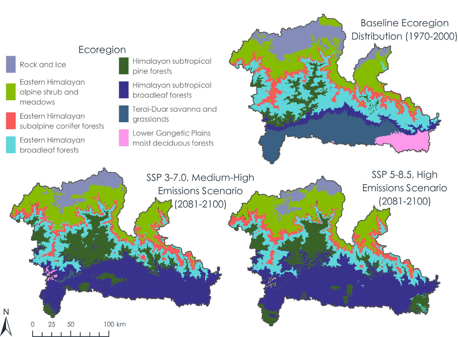
Figure: Historical (1970-2000) and projected (2081-2100) ecoregion distributions defined by environmental stratification and aggregation process using multi-model ensembles under two SSP scenarios, SSP3-7.0 and SSP5-8.5.
The partnership between the University of Michigan and ICIMOD was deemed successful with great lessons learned.
“Our partnership with ICIMOD was crucial for the scoping, development, and completion of this project. We relied heavily on their previous work and wealth of expertise to tailor the project’s research question and ensure that our approach would be useful for researchers, academics, and practitioners moving forward. ICIMOD also played a vital role in providing us (the student team) with context for the HKH region. They directed us toward useful resources and provided us with nuanced perspectives on the socio-ecological relationships at play within the study area.” – Emily Johnson, graduate student team member, University of Michigan.
More information